"La Pointe de la Gay" Hike
- Level red – hard
Distance (km)
:
10
Elevation (m)
:
715
Daily duration (minutes)
:
330
Hiking itinerary

 Departure/Arrival
 Point of interest
Circuit n° 1
LIBELLE_SOUSCARTE
- SITRA services :
- Distance (km) 10
- Elevation (m) 715
- Daily duration (minutes) 330
- References topoguides :
- Cartoguide des itinéraires pédestres en vente à l'Office de Tourisme des Alpes du Léman (Bellevaux,Habère-Poche) 8 €.
- Environment :
- Mountain location
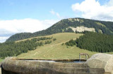
Experience the enjoyment that comes with exploring the Tré le Saix pastures. Venture into the heart of the Swiss Alps for fabulous views of the Roc d'Enfer.
Nature and Heritage:
The Tré le Saix mountain pastures are ideal for bird watching. Be patient, quiet and look through your binoculars to see bullfinches, yellow-billed choughs (choughs living at altitudes of 4000m), ring ouzels (white breasted thrushes that settle in the Alps) and even black grouse. Find out more about our mountain dwellers at Bellevaux’s fauna museum.
Route details:
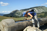
Walk up the path towards Haute Meille. When you reach the last Haute Meille chalet, turn left, continue for 100m then turn right. Walk along the steep path to Tré le Saix mountain pasture. You’ll go past the Moittaz chalets. Once you reach the pastures, turn right towards Pointe de la Gay. You’ll go over Col de Vallonet (1548m) and continue towards Pointe de la Gay (wide path in the woodlands). Turn right when you reach the clearing to reach Pointe de la Gay (1801m). From here, you can go back along the same path or go along the ridge (no signposts) to be level with an electricity pylon and reach the Col de Chavannes. Get off the ridge and turn right onto the hillside along a woodland path. This will then lead onto a forest path and you’ll pass by a ruin, the Chalet des Bourly (1500m). Continue and turn right towards La Combe and you’ll reach the car park.
The Tré le Saix mountain pastures are ideal for bird watching. Be patient, quiet and look through your binoculars to see bullfinches, yellow-billed choughs (choughs living at altitudes of 4000m), ring ouzels (white breasted thrushes that settle in the Alps) and even black grouse. Find out more about our mountain dwellers at Bellevaux’s fauna museum.
Route details:
Walk up the path towards Haute Meille. When you reach the last Haute Meille chalet, turn left, continue for 100m then turn right. Walk along the steep path to Tré le Saix mountain pasture. You’ll go past the Moittaz chalets. Once you reach the pastures, turn right towards Pointe de la Gay. You’ll go over Col de Vallonet (1548m) and continue towards Pointe de la Gay (wide path in the woodlands). Turn right when you reach the clearing to reach Pointe de la Gay (1801m). From here, you can go back along the same path or go along the ridge (no signposts) to be level with an electricity pylon and reach the Col de Chavannes. Get off the ridge and turn right onto the hillside along a woodland path. This will then lead onto a forest path and you’ll pass by a ruin, the Chalet des Bourly (1500m). Continue and turn right towards La Combe and you’ll reach the car park.
Opening day(s)
All year long 2026
Every day
General
- Services :
- Pets welcome
- Motorhomes allowed
- Visites :
- Average individual visit length (minutes) 330
- SITRA services :
- Services
Equipment & Services
- Leisure facilities :
- Picnic area
- Parking :
- Car park


We also suggest...


Contact
Parking du lac de Vallon
La Chèvrerie
74470
Bellevaux
Phone : +33 4 50 73 71 53
Accessibility
Theme:
Share :